|
RustyValkry
|
 |
« on: April 25, 2021, 12:09:46 PM » |
|
I just made a flight reservation to return to Daytona Beach on May 8th. I'll make sure the RustyValkyrie is still running well and head out as soon as I get everything ready . . . hopefully on Sunday the 9th. If the weather turns out to be bad I'll hang in Daytona till I get a window of good weather.
I'll ride to a friends home near Harrisonburg, VA and spend a day or 2, hopefully get to ride with he and his daughter. His daughter, still in high school, just started riding last fall. I figure I'll break the ride from Daytona to Virginia into 2 days as Google Maps says it'll take between 11 and 12 hours. From VA to home is 6 to 7 hours so that's an easy day's ride.
I did a lot of maintenance on the RustyValkyrie over the winter so I'm not much afraid of most of it but there is always something that can happen. The major fear was the gas tank but it came pretty clean and the Pingel has a nice stainless steel screen and I have an inline ceramic filter as well. I THINK I'll get home without either of those getting blocked even if there is 'stuff' in the tank and I don't think there is. I'm thinking the biggest risk is electrical, starter, alternator, relays or connections. BUT, when I sit down on it and head out I'm NOT going to worry about it, I'm going to try to enjoy the ride.
I'll post to this thread as stuff comes up related to this ride, either in preparation or while underway.
|
|
|
|
« Last Edit: April 25, 2021, 03:33:19 PM by RustyValkry »
|
 Logged
|
|
|
|
Valkorado
Member

Posts: 10517
VRCC DS 0242
Gunnison, Colorado (7,703') Here there be twisties.
|
|
« Reply #1 on: April 25, 2021, 02:24:51 PM » |
|
 Been watching your restoration thread, impressive job! Safe and happy trails!
|
|
|
|
|
Logged
|
Have you ever noticed when you're feeling really good, there's always a pigeon that'll come sh!t on your hood? - John Prine 97 Tourer "Silver Bullet" 01 Interstate "Ruby"  |
|
|
|
Jess from VA
|
|
« Reply #2 on: April 25, 2021, 03:31:20 PM » |
|
I wish you clear sailing and tailwinds. I wonder if you have towing on your insurance? (I don't) But adding it just for the maiden voyage might be a comfort. And karma is..... having it, you won't need it. |
|
|
|
|
Logged
|
|
|
|
|
RustyValkry
|
|
« Reply #3 on: April 25, 2021, 03:38:42 PM » |
|
I wish you clear sailing and tailwinds. I wonder if you have towing on your insurance? (I don't) But adding it just for the maiden voyage might be a comfort. And karma is..... having it, you won't need it. I have AAA and it covers towing for my bikes. I didn't think to ask in my first post, does anyone have suggestions about routes from Daytona to Harrisonburg, VA? It'd be nice to avoid interstates, especially if the weather turns out to be nice. I've thought I could do sections of interstate and sections of nice back roads but I'd just be blindly picking each. I'm not really keen on doing a lot of twisties in the hills since this is a maiden voyage of a bike that sat for too long but some nice back roads through farm country or woods would be nice. |
|
|
|
|
Logged
|
|
|
|
|
luftkoph
|
|
« Reply #4 on: April 25, 2021, 06:30:33 PM » |
|
So many options, I wouldn’t even know where to start, but there’s no way around the fact to get from the seaboard to the Shenandoah valley one must negotiate a few curves.
Maybe 17 to us1 into ga. Then 23 to 441 up towards Asheville nc. Then I 26 to the tri cities then pick up us. 11 lee hwy and follow it to Harrisonburg
|
|
|
|
|
Logged
|
Some day never comes
|
|
|
|
Jess from VA
|
|
« Reply #5 on: April 25, 2021, 07:06:47 PM » |
|
I already mentioned the BRP.
If it was me, I'd slab it out of FL 95, 26 up to Ashville NC, and only then think about getting off and riding secondary roads. From Ashville NC, it's only 52miles west to Cherokee NC and the bottom of the BRP.
But making the entire BRP up to Waynesboro VA in one day is a monster day at 45mph, and there better not be any rain or bad weather and you may still end up riding in the dark (with the million deer - no).
To cut that down, you stay on 26 out of Ashelville NC up past Johnson City TN to I-81N, then in Roanoke VA, you can hop over onto the BRP close-by and get on the BRP up to Waynesboro VA, then back over to I-81 to Harrisonburg VA.
Or, get off I-81N just past Roanoke and take 220N North which is also a real nice ride (not as twisty as BRP, but still curvy) up to 33 East which brings you down out of the hills into the backdoor of Harrisonburg VA.
My knowledge of farther south is not good. My routes are what I know.
Another reason to slab the first part of the ride is, if the bike is going to break down or give troubles, it's better to happen on the slab where you will be easy to find and take to a shop in civilization, instead of out in the middle of nowhere (and maybe no Cphone either). (Not a comment on your wrenching, just a comment on karma.)
|
|
|
|
« Last Edit: April 25, 2021, 07:25:21 PM by Jess from VA »
|
Logged
|
|
|
|
hubcapsc
Member
Posts: 16824
upstate
South Carolina
|
|
« Reply #6 on: April 25, 2021, 07:17:50 PM » |
|
I did this in a day recently. It was about 1000 times better than slabbing it up 95 and 26. 26 sucks. 95 probably sucks. The middle of nowhere in Georgia is awesome. I fed this route into my GPS, there's too many turns to "wing it"... https://goo.gl/maps/rz63Zsf2CXbSUCiz5-Mike |
|
|
|
|
Logged
|
|
|
|
|
RustyValkry
|
|
« Reply #7 on: April 25, 2021, 09:19:54 PM » |
|
I did this in a day recently. It was about 1000 times better than slabbing it up 95 and 26. 26 sucks. 95 probably sucks. The middle of nowhere in Georgia is awesome. I fed this route into my GPS, there's too many turns to "wing it"... https://goo.gl/maps/rz63Zsf2CXbSUCiz5-Mike I already mentioned the BRP.
If it was me, I'd slab it out of FL 95, 26 up to Ashville NC, and only then think about getting off and riding secondary roads. From Ashville NC, it's only 52miles west to Cherokee NC and the bottom of the BRP.
But making the entire BRP up to Waynesboro VA in one day is a monster day at 45mph, and there better not be any rain or bad weather and you may still end up riding in the dark (with the million deer - no).
To cut that down, you stay on 26 out of Ashelville NC up past Johnson City TN to I-81N, then in Roanoke VA, you can hop over onto the BRP close-by and get on the BRP up to Waynesboro VA, then back over to I-81 to Harrisonburg VA.
Or, get off I-81N just past Roanoke and take 220N North which is also a real nice ride (not as twisty as BRP, but still curvy) up to 33 East which brings you down out of the hills into the backdoor of Harrisonburg VA.
My knowledge of farther south is not good. My routes are what I know.
Another reason to slab the first part of the ride is, if the bike is going to break down or give troubles, it's better to happen on the slab where you will be easy to find and take to a shop in civilization, instead of out in the middle of nowhere (and maybe no Cphone either). (Not a comment on your wrenching, just a comment on karma.)
So many options, I wouldn’t even know where to start, but there’s no way around the fact to get from the seaboard to the Shenandoah valley one must negotiate a few curves.
Maybe 17 to us1 into ga. Then 23 to 441 up towards Asheville nc. Then I 26 to the tri cities then pick up us. 11 lee hwy and follow it to Harrisonburg
I've done 26 to 77 a few times, if you hit 77 at the wrong time it's a mess. I've been looking at the map, and taking into consideration what Jess said about better to break down on an interstate, I may take I-95 to Fayetteville then thread the needle between Raleigh/Durham and Greensboro to get into Virginia. Just not sure I want to be on the interstate that long. I guess I'll continue to look and decide. Another good thing about taking I-95 out of Florida is I hit a welcome center in Georgia where I can pick up a map . . . a real map . . . made of paper . . . that I can lay out on a table and study -- I'm old you know.  It's a PITA to try to study a map on a computer screen. It's always the wrong size. |
|
|
|
|
Logged
|
|
|
|
|
Jess from VA
|
|
« Reply #8 on: April 25, 2021, 10:44:25 PM » |
|
Rusty, I hope you know I'm not trying to spread any doom and gloom (or negative waves) with my comments about tow coverage and road breakdowns. A lot of guys who have pretty reliable bikes will still run a 200 mi day (esp in spring) before taking any longer trip. Just for a shakedown. Breaking down on any interstate is no joy, my point was more to shake the bike down good on the first day, and don't stray too far off the beaten path until confidence is built. I promise I am only sending positive waves for your ride up East.  I've never had a GPS or cell phone. I study computer maps and hand write my route (road numbers, distances and turns) on paper before I go. It goes in my tank bib clear window. Some guys write it on blue painters tape and stick it on the windshield (maybe day by day). With duel tripmeters (at least on my Interstates), I can zero #2 at every turn, then consult my crib sheet for miles to next turn (so I'm not having to check each cross street or exit along the way). Tripmeter #1 is always zeroed at gas fill-ups (habit from bikes with no fuel gauge; I go 220 to reserve on both bikes, though I slow feed fill to the neck every time). You might as well start recording gallons and miles when you leave, so you get an idea how far you get to reserve (try to be consistent on how full you get your tank). You hit reserve, you Zero #1 tripmeter and pray for gas inside 30 miles (to be safe). But earlier gas stops gives you more rest stops. I can print out whole maps, but I find it difficult to consult them closely while underway  (but I might put some of those in the bags for motel viewing). |
|
|
|
« Last Edit: April 26, 2021, 08:34:43 AM by Jess from VA »
|
Logged
|
|
|
|
|
RustyValkry
|
|
« Reply #9 on: April 26, 2021, 08:34:21 AM » |
|
I've been working on a route north. I've used paper maps AND Google maps. Here's what I have so far.
I decided the best way to pick a route was to work backwards from my destination. Making that decision got me to Danville, VA by using route 29 to route 33. Below is what I've come up with starting in Daytona Beach.
I-95 to I-26
I-26 to 601
601 into Camden, SC
601 to route 1 at the corner of W. DeKalk and Broad Street
Route 1 joins 501 just south of Sanford.
Route 501 to route 86 just south of Chapel Hill
Route 86 to Danville.
Route 29 to route 33.
My friend actually lives near Port Colton, VA so I'll have to cut off route 33 right at the bottom of the ridge.
It wasn't until I started typing this that I figured out the final leg of Route 86. If I have nice weather I think this will be a great ride. Lots of the roads I've chosen are through farm country and forest.
I'll continue to study the route to see if I'm made any mistakes or if there's something better but I think this is close to final.
I left gear in Daytona for the ride. I have my mesh jacket, textile riding pants, boots and helmet along with other clothes for off the bike. I put my old HD SAC seat bag on the RustyValkyrie. Along with the saddlebags I'll have plenty of space. I'll wear one of my leather jackets on the flight down cause I don't think it's going to be warm enough for mesh once I get out of FL. I had the forethought to take my seat covers with me last fall which I left for the trip. I have a sheep skin and a bead seat cover. With the Corbin seat I have I'm going to need one or the other - or both.
Like the other thread asked, "do you get excited about a ride?" . . . Yep. Wish I could leave now. If the weather is warm this could be an great ride for me, the Carolinas in May.
|
|
|
|
|
Logged
|
|
|
|
|
Jess from VA
|
|
« Reply #10 on: April 26, 2021, 08:46:25 AM » |
|
Rain gear? (is also hot gear, but it can become cold gear in a pinch) (never get a one piece jumper, you have to be a freekin' gymnast to get them on and off). Two piece, in and out of rain, you can bungy the jacket behind you and leave the pants on so you don't die of heat stroke, but if it rains it's ass off again, you can just stop and reach back and put it back on quickly. And spare gloves, if yours get water logged. Masks for the 7/11's? (in VA anyway) I've worn helmets into 7/11's for many years (esp when I don't want to take time to lock it up for a 3 minute stop, and the loiterers outside look like they might steal it, just for grins). But sometimes, wearing a helmet into a 7/11 (or other convenience store) makes everyone think you are there for an armed robbery. (Mine are halfs so I smile a lot) (and I'm always armed) |
|
|
|
« Last Edit: April 26, 2021, 08:52:55 AM by Jess from VA »
|
Logged
|
|
|
|
hubcapsc
Member
Posts: 16824
upstate
South Carolina
|
|
« Reply #11 on: April 26, 2021, 08:59:26 AM » |
|
It's a PITA to try to study a map on a computer screen. It's always the wrong size.??? a paper map is always the same size. A map on a computer screen is always whatever size you want it to be. I used to navigate with these:  The texas one is the size of a phone book. Now I use this: 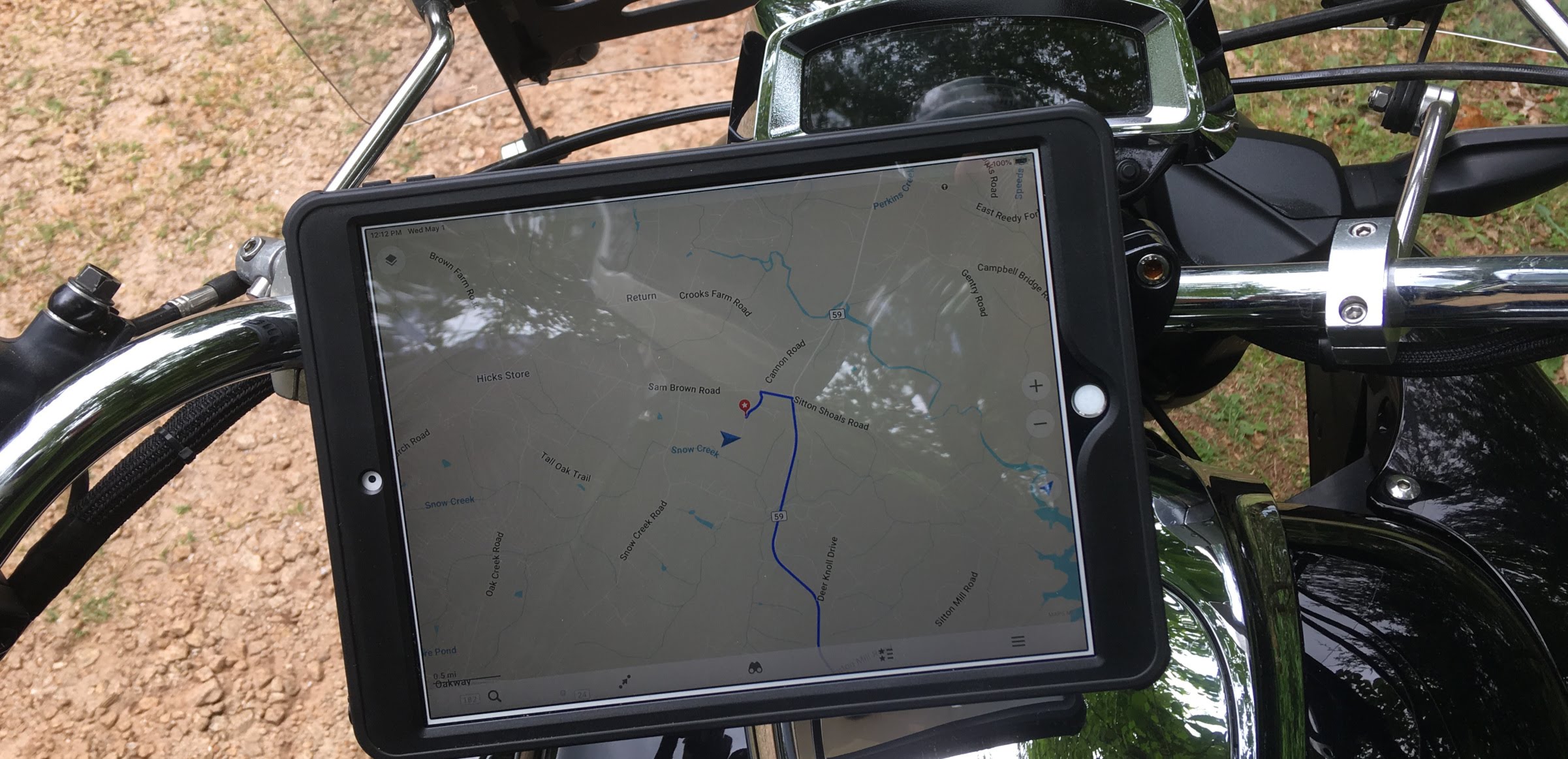 It is always on the right page, always zoomed in the right amount, and there's a little man that represents me, where I am and what direction I am going... I used it to follow the impossible route I posted above, and on many other adventures, including backroads from South Carolina to Arizona... I have a road I like to take across South Carolina... route 34... I always make sure to drop down to I-20 before I hit Camden :-) ... -Mike
|
|
|
|
« Last Edit: April 26, 2021, 09:04:35 AM by hubcapsc »
|
Logged
|
|
|
|
|
luftkoph
|
|
« Reply #12 on: April 26, 2021, 10:49:40 AM » |
|
You said you had AAA they have decent state maps I think they are free to members, you can get them at a local AAA ofice
|
|
|
|
|
Logged
|
Some day never comes
|
|
|
|
RustyValkry
|
|
« Reply #13 on: April 26, 2021, 10:52:37 AM » |
|
Rain gear? (is also hot gear, but it can become cold gear in a pinch) (never get a one piece jumper, you have to be a freekin' gymnast to get them on and off). Two piece, in and out of rain, you can bungy the jacket behind you and leave the pants on so you don't die of heat stroke, but if it rains it's ass off again, you can just stop and reach back and put it back on quickly. And spare gloves, if yours get water logged. Masks for the 7/11's? (in VA anyway) I've worn helmets into 7/11's for many years (esp when I don't want to take time to lock it up for a 3 minute stop, and the loiterers outside look like they might steal it, just for grins). But sometimes, wearing a helmet into a 7/11 (or other convenience store) makes everyone think you are there for an armed robbery. (Mine are halfs so I smile a lot) (and I'm always armed) Yes, I left 2 jackets suitable for use in the rain and 2 pair of gloves, neither of which is suitable for rain. I'll have at least 1 mask with me since I have to wear one on the flight down. The biggest problem for me when riding in wet or cold conditions is my legs. Pants legs are never long enough and the wind gets up to my knees or above. A few years ago I finally found a pair of light weight snow gaiters that I tried and the difference was huge, no more cold legs. I'll have to find them and put them in my jacket pocket before I fly down. |
|
|
|
|
Logged
|
|
|
|
|
RustyValkry
|
|
« Reply #14 on: April 26, 2021, 11:20:43 AM » |
|
It's a PITA to try to study a map on a computer screen. It's always the wrong size.??? a paper map is always the same size. A map on a computer screen is always whatever size you want it to be. I used to navigate with these: The texas one is the size of a phone book. Now I use this: It is always on the right page, always zoomed in the right amount, and there's a little man that represents me, where I am and what direction I am going... I used it to follow the impossible route I posted above, and on many other adventures, including backroads from South Carolina to Arizona... I have a road I like to take across South Carolina... route 34... I always make sure to drop down to I-20 before I hit Camden :-) ... -Mike I have been using both planning my route. The paper map gives me a overview and I can zoom in on my computer to see details. If I have a problem on the road I can pull over and check Google Maps but I don't want to deal with mounting my phone for the ride, even if I could see the phone well enough to follow the directions. I've always memorized the route changes for each day's ride. I think I'll try Jess' suggestion of masking tape on the windshield which is all I usually need. Talking about Google Maps, I had an incident on the way back from Daytona a week ago. I was on I-64 heading across toward Staunton, VA and got off for Gas. The station, a Sheetz, was close to the interchange so I figured Maps would send me back to that interchange but it didn't. It sent me the opposite direction which I thought strange but hey, you use Maps then you use Maps so I set out. A little way up the road 'she' told me to turn left in a quarter mile - hmmmm, seems strange but hey, you use Maps then you use Maps so I made the turn. It was a divided street and as soon as I made the turn, 'she' told me to take the third exit off the traffic circle. Traffic circle!? - where is this thing sending me, but hey, you use Maps then you use Maps so I went on . . . about a block where I came face to face with a closed gate - THE BITCH!!!!! There ensued a stream of invective directed at 'her' as I realized I'd have to back the trailer up on an unlit, divided street knowing a car could come in anytime. I couldn't tell depth behind me and I had to clear the divider before I could swing the trailer across the other lanes. I couldn't risk backing the trailer out onto the street I came off because I had no line of sight in either direction. I succeeded in backing up and getting the trailer across the road and started pulling forward to get back on the street I turned off when I saw 2 cars coming toward me. Of course 1 wanted to turn into the street that I have completely blocked. I figured the person would wait for a few seconds while I pulled out but no! - she was going to get past me in her Mercedes - no matter what so she proceeded to drive right up onto the sidewalk and squeeze past me - oh well - but hey, you use Maps then you use Maps so I went on my way. |
|
|
|
|
Logged
|
|
|
|
hubcapsc
Member
Posts: 16824
upstate
South Carolina
|
|
« Reply #15 on: April 26, 2021, 11:40:33 AM » |
|
so I figured Maps would send me back to that interchange but it didn't. I don't use google maps on my phone as a GPS... I've never gotten along with GPSes that tell me where to go, that's why I always used paper maps until recently... I think I agree with you 100% on paper maps in that respect. I noodle around with google maps (mymaps.google.com) on my computer while sitting in my easy chair... mymaps.google.com differs from maps.google.com in numerous ways, but is real similar. mymaps has a feature where you can download routes you create in "gpx" format. The "gps" on my motorcycle is really a 10.5 inch ipad in a waterproof case. The ipad has a built-in gps chip and has all the map data downloaded onto it. I use an app I pay $5 a year for to display my maps, and the app knows how to ingest my gpx routes. My "gps" doesn't tell me where to go, I tell it where I want to go and then I just try to keep the little man on the blue line ... I'm lost the whole time I'm moving, but when I get to the end of the blue line, I'm at my destination. 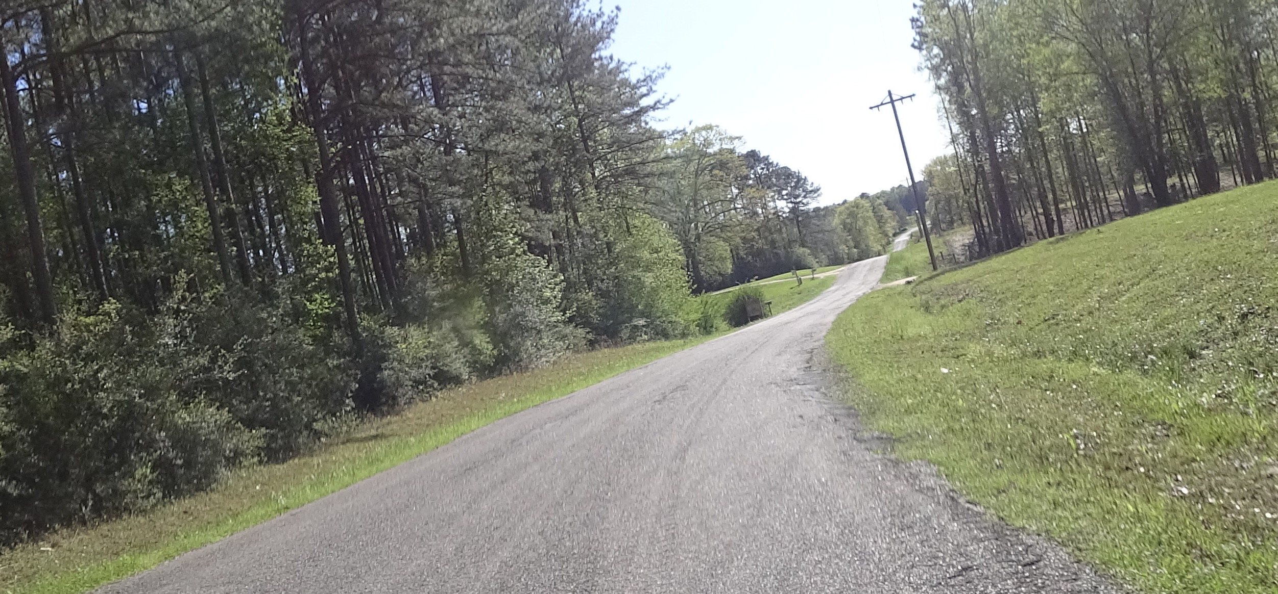 -Mike
|
|
|
|
« Last Edit: April 26, 2021, 11:42:55 AM by hubcapsc »
|
Logged
|
|
|
|
Skinhead
Member
Posts: 8762
J. A. B. O. A.
Troy, MI
|
|
« Reply #16 on: April 26, 2021, 12:12:55 PM » |
|
I think I'll try Jess' suggestion of masking tape on the windshield which is all I usually need.
A technique I used in the past is to just write the directions on my windshield with a sharpie (not waterproof) or a grease pencil (waterproof, but a little harder to write with) 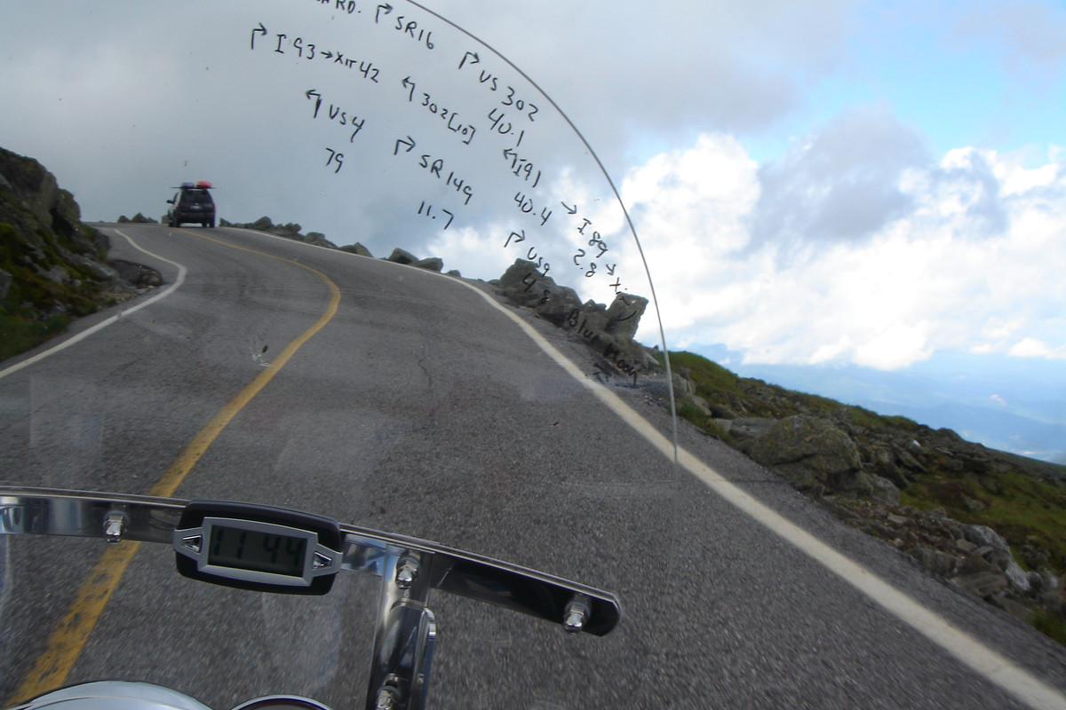 |
|
|
|
|
Logged
|
 Troy, MI |
|
|
|
Jess from VA
|
|
« Reply #17 on: April 26, 2021, 02:17:48 PM » |
|
I'm lost the whole time I'm moving, but when I get to the end of the blue line, I'm at my destination.This sounds a lot like Christopher Columbus. (and many others) The biggest problem for me when riding in wet or cold conditions is my legs. Pants legs are never long enough and the wind gets up to my knees or above. A few years ago I finally found a pair of light weight snow gaiters that I tried and the difference was huge, no more cold legs.Common problem. All my riding pants are longer than my walking pants. I wear 18" Waterproof MC boots (no front openings, side Velcro) on trips. I have insulated and/or waterproof pants, and rain pants or bibs will do a good job in cold (most strap under the boots). I have good chaps and used them many years, but rarely do anymore. Same with most of my nice leather... I wear mostly textile-everything anymore. Lighter weight, better range of motion, vents everywhere, water and wind proof, dry quickly. I also carry military boot blowsers (rubber bands with hooks) to clamp my pants legs to my legs (pants turned underneath the bands), above my boots (just to keep the air out, if that's all I need). I gave some to Hubcap a few years ago, but he prefers to tuck his pants in his sox.
|
|
|
|
« Last Edit: April 26, 2021, 02:37:20 PM by Jess from VA »
|
Logged
|
|
|
|
|
RustyValkry
|
|
« Reply #18 on: April 26, 2021, 03:18:49 PM » |
|
I think I'll try Jess' suggestion of masking tape on the windshield which is all I usually need.
A technique I used in the past is to just write the directions on my windshield with a sharpie (not waterproof) or a grease pencil (waterproof, but a little harder to write with) I've thought of trying to use a grease pencil to write the mileage on the speedo face when I get gas on my bikes that only have one trip odometer but I've never come across a grease pencil when I'm in the store and think to look. Masking tape you can get anywhere which is why I thought I might try that. I'm reluctant to use a sharpie for fear that I'd get the wrong one and end up with permanent directions on my windshield.  |
|
|
|
|
Logged
|
|
|
|
|
Jess from VA
|
|
« Reply #19 on: April 26, 2021, 03:32:58 PM » |
|
Painters tape will come off with no goo, masking tape won't.
|
|
|
|
|
Logged
|
|
|
|
|
|
|
ridingron
|
|
« Reply #21 on: April 26, 2021, 06:15:31 PM » |
|
I like to take 321 off I-95 just north of Savannah near Hardeeville. Several choices for gas, eats and treats. 321 runs all the way to just south of Columbia. Be aware it is a 2 lane road and a little desolate. |
|
|
|
|
Logged
|
|
|
|
Skinhead
Member
Posts: 8762
J. A. B. O. A.
Troy, MI
|
|
« Reply #22 on: April 26, 2021, 06:17:11 PM » |
|
Dry erase markers work as well, but they won't last in rain, neither will a sharpie permanent marker. The problem with masking tape is it can pull the coating off your windshield.
|
|
|
|
|
Logged
|
Troy, MI |
|
|
|
The emperor has no clothes
|
|
« Reply #23 on: April 26, 2021, 06:19:48 PM » |
|
I usually just get lost and make my buddies wait out in the hot desert for me. |
|
|
|
|
Logged
|
|
|
|
|
RustyValkry
|
|
« Reply #24 on: April 26, 2021, 07:14:09 PM » |
|
I don't carry a jumper yet but I've been carrying a 12 volt compressor for a couple decades, in fact the same one for a couple decades. I'm not going to say anything about not having problems since, if I do, you know I will.  |
|
|
|
|
Logged
|
|
|
|
|
RustyValkry
|
|
« Reply #25 on: April 26, 2021, 07:22:39 PM » |
|
I like to take 321 off I-95 just north of Savannah near Hardeeville. Several choices for gas, eats and treats. 321 runs all the way to just south of Columbia. Be aware it is a 2 lane road and a little desolate. I'll take a look at that route. Thanks. I could go up 321 and catch either 601 or 301 both of which would bring me out right where I would have gotten to if I had taken I-95 to I-26. I guess weather and time could be the 2 deciding factors. |
|
|
|
|
Logged
|
|
|
|
|
RustyValkry
|
|
« Reply #26 on: April 26, 2021, 07:37:29 PM » |
|
Dry erase markers work as well, but they won't last in rain, neither will a sharpie permanent marker. The problem with masking tape is it can pull the coating off your windshield.
I'll check with some local stores for grease pencils. Maybe some day I'll remember to look for them when I'm in a store that has them. |
|
|
|
|
Logged
|
|
|
|
|
RustyValkry
|
|
« Reply #27 on: May 01, 2021, 09:55:57 AM » |
|
A couple days ago I was at my local hardware store and remembered to check for grease pencils. One of the folks working there led me to the right place in the right idle where she rummaged around for a while and found the last one, a green one. I spent the huge sim of $1.99 for it. Now if the TSA doesn't confiscate it be as a deadly weapon I'll havey way of writing my route on my windshield and my milage on the speedo for calculating gas mileage.
|
|
|
|
|
Logged
|
|
|
|
Oss
Member
Posts: 12880
The lower Hudson Valley
Ossining NY Chapter Rep VRCCDS0141

|
|
« Reply #28 on: May 01, 2021, 01:15:43 PM » |
|
I lost my fred flinstone gps in alabama
It was a waterproof case that had a cheap mount (how I lost it) in road construction rilding with Wild6 on the way back from GOTF after we left the cool kids like Tbird rip
Take 3x5 index cards and write the road # and distance to next road turn and r or l
at end stop, turn over card or go to next one
On the police bike I have a clip on the tank that I can put paper on as well but of course NOT waterproof
|
|
|
|
|
Logged
|
If you don't know where your going any road will take you there
George Harrison
When you come to the fork in the road, take it
Yogi Berra (Don't send it to me C.O.D.)
|
|
|
|
RustyValkry
|
|
« Reply #29 on: May 01, 2021, 02:11:52 PM » |
|
I lost my fred flinstone gps in alabama
It was a waterproof case that had a cheap mount (how I lost it) in road construction rilding with Wild6 on the way back from GOTF after we left the cool kids like Tbird rip
Take 3x5 index cards and write the road # and distance to next road turn and r or l
at end stop, turn over card or go to next one
On the police bike I have a clip on the tank that I can put paper on as well but of course NOT waterproof
Another COB idea that appeals to me. Thanks. |
|
|
|
|
Logged
|
|
|
|
|
RustyValkry
|
|
« Reply #30 on: May 07, 2021, 05:52:07 PM » |
|
I fly out of Allentown, PA tomorrow at 3:22 and arrive in Orlando Sanford at 5:42. I'll have to take a Lyft to get to Daytona.
As soon as I get to the house I'll check over the RustyValkyrie, fire it up and head out to the local Walmart for a few things I'll need for the ride north. That'll be the last shake down ride and a short one at that.
I keep telling myself that I did good work on the resurrection but there's always that irrational fear that I missed something.
Assuming it starts, runs and rides I'll leave early-ish Sunday morning. I'll try to remember to take a short walk around video before I head out. It looks like the weather could go either way on the trip up. Maybe I'll get lucky and ride between fronts and maybe I won't and ride into every shower the whole way up, who knows. I'm remaining flexible on the route I take, I could make last minute changes depending on the weather, how I feel, etc. I'll try to remember to take pictures during stops that I can post in the evenings. I tend to be pretty bad about remembering that sort of thing.
I'll try to remember to post again tomorrow night before I hit the rack. I'm not taking this laptop so everything after this post will be done of the phone.
|
|
|
|
|
Logged
|
|
|
|
Skinhead
Member
Posts: 8762
J. A. B. O. A.
Troy, MI
|
|
« Reply #31 on: May 08, 2021, 04:51:35 AM » |
|
Good luck.
|
|
|
|
|
Logged
|
Troy, MI |
|
|
|
RustyValkry
|
|
« Reply #32 on: May 09, 2021, 07:33:19 AM » |
|
First gas stop just north of Jacksonville. I'm not going to calculate mileage on this tank.
Bike is running well so far.
The combination of sheep skin and bead covers seem to be working as my butt doesn't hurt. Time will tell.
|
|
|
|
« Last Edit: May 09, 2021, 07:36:10 AM by RustyValkry »
|
Logged
|
|
|
|
|
Timbo1
|
|
« Reply #33 on: May 09, 2021, 06:25:00 PM » |
|
Hope you have a safe & trouble free trip. Ride safe.
|
|
|
|
|
Logged
|
|
|
|
|
RustyValkry
|
|
« Reply #34 on: May 09, 2021, 07:54:22 PM » |
|
I got off the road at about 8:30 this evening.
The ride went well if overly long. For the last couple hours I was keeping my eyes open for a motel but, as it seems to happen, I see motels until I want to see them.
The bike ran well. The seat sucks, the hand grips suck but for the most part there's a lot to like.
I'll add more 2Dwhen I'm not so tired.
|
|
|
|
|
Logged
|
|
|
|
Oss
Member
Posts: 12880
The lower Hudson Valley
Ossining NY Chapter Rep VRCCDS0141
|
|
« Reply #35 on: May 10, 2021, 01:25:22 AM » |
|
Been there
RUSSELL Day long
Never again without it since 2005
|
|
|
|
|
Logged
|
If you don't know where your going any road will take you there
George Harrison
When you come to the fork in the road, take it
Yogi Berra (Don't send it to me C.O.D.)
|
|
|
|
RustyValkry
|
|
« Reply #36 on: May 10, 2021, 08:12:10 PM » |
|
|
|
|
|
|
Logged
|
|
|
|
Oss
Member
Posts: 12880
The lower Hudson Valley
Ossining NY Chapter Rep VRCCDS0141
|
|
« Reply #37 on: May 11, 2021, 05:16:07 AM » |
|
Is that west of 81 at the bottom of Va ?
|
|
|
|
|
Logged
|
If you don't know where your going any road will take you there
George Harrison
When you come to the fork in the road, take it
Yogi Berra (Don't send it to me C.O.D.)
|
|
|
|
RustyValkry
|
|
« Reply #38 on: May 11, 2021, 06:00:47 AM » |
|
Is that west of 81 at the bottom of Va ?
It's mid Shenandoah Valley about 10 miles east of 81. The view is of the Shenandoah National Park in the Blue Ridge Mountains. |
|
|
|
|
Logged
|
|
|
|
DDT (12)
Member
Posts: 4139
Sometimes ya just gotta go...
Winter Springs, FL - Occasionally...
|
|
« Reply #39 on: May 11, 2021, 08:35:11 AM » |
|
Rusty,
Fabulous adventure! Thanks for taking us along... Discovering new things: about our rides, ourselves, our country and its people, is one of those things that tingle us right down to the marrow of our bones! Many of us here know what you're experiencing, and we share your delight! Great photos, too... I love that country... can't wait to revisit it!
I'm glad your Valk is holding up well... and, I commend you for your restoration work and obvious good results. As for the seat, grips, and other minor things, you'll solve those over time as you and your baby get to know each other better... and as you decide what works best for your own particular needs... You've taken a big step on a long journey... good luck as you continue on!!!
DDT
|
|
|
|
|
Logged
|
Don't just dream it... LIVE IT!
See ya down the road...
|
|
|
|


