Valkyrie Riders Cruiser Club
June 20, 2025, 01:11:50 PM *
Welcome, Guest. Please login or register.

Login with username, password and session length
Ultimate Seats Link VRCC Store
Homepage : Photostash : JustPics : Shoptalk : Old Tech Archive : Classifieds : Contact Staff
News: If you're new to this message board, read THIS!
 
Inzane 17
Pages: [1]   Go Down
Print
Author Topic: An old can of worms. GPS  (Read 1653 times)
da prez
Member
*****
Posts: 4354

. Rhinelander Wi. Island Lake Il.


« on: December 14, 2023, 05:46:26 AM »

  Im planning on a new GPS. My old one is not water resistant. I'm not looking for the top , but good. For the bike and in the truck.

                                            da prez
Logged
carolinarider09
Member
*****
Posts: 12393


Newberry, SC


« Reply #1 on: December 14, 2023, 07:09:52 AM »

In my opinion, there are only a couple of choices.   The first link below supports the Garmin based systems.  But the link directly below thiis sentence points to a spot on the forum where I asked the following question.  Which GPS Now?   I believe it will help answer your question.   

https://www.zumouserforums.co.uk/viewtopic.php?t=2621

Oh and I did find a Garmin 590 for sale for $300.  It is used and I was strongly interested in it but.....

My background in GPS use. 

First GPS was a Magellan GPS.  It did not allow me to do "routing" but it did show where I was and how fast I was going.  A benefit for me on the bike. (first image below)

Second GPS was a Garmin 6530 (forget the number and second image below).  It allowed route planning but its ability to play music was somewhat limited and I soon replaced it with another Garmin device. That Garmin device allowed me to use XM Radio (you can see the antenna in the picture). I got hooked on Audio Books via this GPS

Third GPS was a Garmin Zumo 550.  I have used that device since I discarded the Garmin mentioned above.  I still have it.  It rides in my 1996 Ford Explorer.  I believe a I purchased it sometime in 2008.  Third Image below

The Garmin Zumo 550 had some issues but it worked well for my trips out west and all over the southeast and north.  I had its buttons replaced and one other thing so its operational today and still has Garmin Maps.

My Fourth GPS and the one I still depend on today is a Garmin 665 (fourth Image below).   It is still in service and has had its memory upgraded to 16GB.  However that did not stop Garmin from dropping lifetime maps for the 665 this year.  It's the fourth image below.  I also purchased a Garmin 660 as a backup GPS since I do depend on the GPS for routing on my trips.  I am also able to reprogram routes while on the road using my laptop which I take along.  There are some issues with routing software and I am lucky in that I am still able to use Microsoft Streets and Trips.   Not a real fan of Basecamp. 


https://www.zumouserforums.co.uk/index.php?sid=88a91baf37532e39aec2aaa63a3f5d00

Magellan a GPS (I still have it and it does work)


Garmin 6530 or Something like that)


Garmin Zumo 550


Garmin Zumo 665
Logged

scooperhsd
Member
*****
Posts: 5697

Kansas City KS


« Reply #2 on: December 14, 2023, 07:42:15 AM »

I bought a Garmin Zumo 396 which works great, but I think it has been discontinued (but currently still available on Amazon apparently). It has been replace with Zumo XT / Zumo XT2 - if they're as good as the 396 you should be happy with any of them. You will probably have to buy an Auto mount kit (for auto power supply) for them for use in a vehicle.
Logged
michaelyoung254
Member
*****
Posts: 307


Huntsville, Texas


« Reply #3 on: December 14, 2023, 10:04:26 AM »

I have a Garmin Zumo 660. If and when it dies, I won't bother to replace it and will simply use my iPhone with a waterproof case.

I like the GPS itself, but the software (Garmin BaseCamp) absolutely sucks. I like to consider myself fairly "tech savvy" (taught multiple computer programs such as AutoCAD, Inventor, Chief Architect etc... as well as Computer Maintenance & Cisco Networking for several years); however, I find the BaseCamp routing software to be extremely cumbersome and complicated. I will say this though, I don't use the software to plan my routing for my trip very often which I'm sure makes it much more complicated and cumbersome. It's hard to remember everything on a program that you don't use very often. I'm sure that if someone uses it on a regular basis, it'd get much easier once you learned the ins and outs of the program.

With that being said, IMHO, Google Maps is a thousand times better because it's substantially more user friendly and on top of that, it's free!

Save yourself a bunch of money and get a waterproof phone case for your bike. I just did a quick search on Amazon under the tag "Waterproof Phone Case for Motorcycle" and found several from about $25.00 and up.
Logged

1998 Standard - Pearl Sedona Red & Ivory Cream


Serk
Member
*****
Posts: 21791


Rowlett, TX


« Reply #4 on: December 14, 2023, 11:31:41 AM »

Same on the discreet GPS to phone pipeline - I had a Zumo 550, Zumo 660, maybe a few others, but last 10 years or so I use a waterproof Samsung Galaxy phone (Currently an S22 Ultra) mounted in a waterproof wireless charging mount on the bike.

One less thing to keep up with, plus the maps are real time updated (I'm sure the discreet units can do that now too, but) with known speed traps, current wrecks, construction, etc...
Logged

Never ask a geek 'Why?',just nod your head and slowly back away...


IBA# 22107 
VRCC# 7976
VRCCDS# 226

1998 Valkyrie Standard
2008 Gold Wing

Taxation is theft.

μολὼν λαβέ
scooperhsd
Member
*****
Posts: 5697

Kansas City KS


« Reply #5 on: December 14, 2023, 12:11:58 PM »

I have a Garmin Zumo 660. If and when it dies, I won't bother to replace it and will simply use my iPhone with a waterproof case.

I like the GPS itself, but the software (Garmin BaseCamp) absolutely sucks. I like to consider myself fairly "tech savvy" (taught multiple computer programs such as AutoCAD, Inventor, Chief Architect etc... as well as Computer Maintenance & Cisco Networking for several years); however, I find the BaseCamp routing software to be extremely cumbersome and complicated. I will say this though, I don't use the software to plan my routing for my trip very often which I'm sure makes it much more complicated and cumbersome. It's hard to remember everything on a program that you don't use very often. I'm sure that if someone uses it on a regular basis, it'd get much easier once you learned the ins and outs of the program.

With that being said, IMHO, Google Maps is a thousand times better because it's substantially more user friendly and on top of that, it's free!

Save yourself a bunch of money and get a waterproof phone case for your bike. I just did a quick search on Amazon under the tag "Waterproof Phone Case for Motorcycle" and found several from about $25.00 and up.

God yes - Basecamp is not a very user friendly piece of software to use. However, you CAN use the Harley Davidson trip planner and it can output maps that you can upload into your Garmin. I'm not if I've ever seen positive comments anywhere on the web about Basecamp. The HD trip planner has it's quirks also, but it is more intuitive to setup a trip in.

regarding phone vs dedicated GPS - I prefer the GPS - even if the maps don't get updated as often (Garmin typically updates maps 3 times per year). If you haven't downloaded offline maps onto your phone,  you may drive into a place where you may have GPS signal, but no map (I ran into one of these in OK this last summer, on the way to Pawhuska). There is a feature with the later models of Garmins that you can load some software app on your phone, and your Garmin  can get realtime traffic updates via your phone. Works pretty decently.

At least on Android, you can get some other GPS programs and Maps that closely resemble a dedicated GPS. Again, you need the waterproof phone case as well.
« Last Edit: December 14, 2023, 12:19:16 PM by scooperhsd » Logged
Willow
Administrator
Member
*****
Posts: 16597


Excessive comfort breeds weakness. PttP

Olathe, KS


WWW
« Reply #6 on: December 14, 2023, 01:16:26 PM »

I live in Olathe.  If it's not a Garmin it's not a GPS.

That said, some years ago I switched from using a GPS to using my iPhone mapping app.  The iPhone gives more descriptive directions and is constantly updated as you are not dependent upon the updates being loaded to your machine.  There is the small issue of a need for the phone to connect to network but that hasn't been a significant negative.
Logged
Jess from VA
Member
*****
Posts: 30405


No VA


« Reply #7 on: December 14, 2023, 01:30:12 PM »

I write turn by turn directions on paper (from maps on my computer) and stick it low on the inside of my windshield using blue painters tape.   On longer trips, I had more than one piece of paper.  Grin

I've heard of GPS's. 
Logged
Avanti
Member
*****
Posts: 1403


Stoughton, Wisconsin


« Reply #8 on: December 15, 2023, 05:02:36 AM »

I use my phone mounted in a quad lock with an app called Scenic. I use the phone in airplane mode so no data is being used. Maps are all off line in the phone and you can set up any route you can dream up. No phone service ever needed. I am often where there is no service and that is where I like to be.
Logged

Hook#3287
Member
*****
Posts: 6429


Brimfield, Ma


« Reply #9 on: December 15, 2023, 07:12:25 AM »

I get it that many feel it's more convenient to have their phone mounted on the handlebars and use it as a map guidance tool.

I prefer to have the phone in my pocket incase of unexpected dismounting.  But that's just me.

In my car or truck I use my phone, which works very well.

I've used the Garmin Nuvi for years and have always been happy with it's performance and ease of use.  Although not weather resistant, I would remove it when I needed too and generally just didn't use it in the rain.

Recently though, I upgraded to a Garmin Zumo, which I switch between my Wing and my Quad.

The mounting is excellent and easy to move from one to the other once you set it up, but in general it's a good upgrade from the older Garmins.

I use it on the Wing because the Honda GPS system, to put it bluntly, sucks.

I continue to use the older Garmins on the Valks.

Out of all the tech advances we've witnessed over the 20+ years of Valk ownership, I feel the GPS is the most useful and is really the only tech I use.

I've discovered so many excellent roads, I would never have, if not for the GPS.
Logged
Avanti
Member
*****
Posts: 1403


Stoughton, Wisconsin


« Reply #10 on: December 15, 2023, 08:13:07 AM »

I get it that many feel it's more convenient to have their phone mounted on the handlebars and use it as a map guidance tool.

I prefer to have the phone in my pocket incase of unexpected dismounting.  But that's just me.

In my car or truck I use my phone, which works very well.

I've used the Garmin Nuvi for years and have always been happy with it's performance and ease of use.  Although not weather resistant, I would remove it when I needed too and generally just didn't use it in the rain.

Recently though, I upgraded to a Garmin Zumo, which I switch between my Wing and my Quad.

The mounting is excellent and easy to move from one to the other once you set it up, but in general it's a good upgrade from the older Garmins.

I use it on the Wing because the Honda GPS system, to put it bluntly, sucks.

I continue to use the older Garmins on the Valks.

Out of all the tech advances we've witnessed over the 20+ years of Valk ownership, I feel the GPS is the most useful and is really the only tech I use.

I've discovered so many excellent roads, I would never have, if not for the GPS.


I do have a phone in my pocket, one I can turn on if need be. But if no connection than does not matter if in pocket or not. I use a old phone that I bought for $10. And I carry a duplicate with too.  

Can not buy a GPS for $10 and set up your trip very easily sitting by the campfire.
« Last Edit: December 15, 2023, 08:16:02 AM by Avanti » Logged

Serk
Member
*****
Posts: 21791


Rowlett, TX


« Reply #11 on: December 15, 2023, 08:17:22 AM »

Just another observation - for anyone who wants to keep a phone on their person for unplanned get offs, ANY phone, even one without an active plan or SIM can dial 911, as long as it has power (And is new enough to work on current cell networks.)

Dig up that older phone in your drawer, charge the battery, and keep it on your person just for emergencies...

Logged

Never ask a geek 'Why?',just nod your head and slowly back away...


IBA# 22107 
VRCC# 7976
VRCCDS# 226

1998 Valkyrie Standard
2008 Gold Wing

Taxation is theft.

μολὼν λαβέ
Avanti
Member
*****
Posts: 1403


Stoughton, Wisconsin


« Reply #12 on: December 15, 2023, 08:19:35 AM »

Just another observation - for anyone who wants to keep a phone on their person for unplanned get offs, ANY phone, even one without an active plan or SIM can dial 911, as long as it has power (And is new enough to work on current cell networks.)

Dig up that older phone in your drawer, charge the battery, and keep it on your person just for emergencies...


Yes but still needs a connection or no 911 call can be made.
Logged

Hook#3287
Member
*****
Posts: 6429


Brimfield, Ma


« Reply #13 on: December 15, 2023, 10:07:03 AM »

Just another observation - for anyone who wants to keep a phone on their person for unplanned get offs, ANY phone, even one without an active plan or SIM can dial 911, as long as it has power (And is new enough to work on current cell networks.)

Dig up that older phone in your drawer, charge the battery, and keep it on your person just for emergencies...


Yes but still needs a connection or no 911 call can be made.
Absolutely, both good ideas/statements. 

Here in the Lower North East, there's service just about everywhere, so using a older phone for 911 should work.  As long as you remember to keep it charged.

I sometimes forget that kinda of stuff.
Logged
carolinarider09
Member
*****
Posts: 12393


Newberry, SC


« Reply #14 on: December 15, 2023, 06:37:54 PM »


I've discovered so many excellent roads, I would never have, if not for the GPS.


I agree with the above.  By using "Waypoints" in the Garmin system, for routing, and letting the GPS do the route, I have found many, many roads that I never would have traveled and many things that I probably would not have encountered in my rides. 

Yes, I plan trips.  Using the waypoints in the Garmin system, simply sets up places I want to travel to not specifically the roads I will travel to get there.  And yes, there are times when I used the waypoints to to travel a specific road (like the BRP).   

In addition, I am sort of “old school”.   I don’t like to depend on a single device if I an afford not to.  Cell phones are for phone calls and texting and, if needed, accessing some specific programs while away from home.  If you also depend on it to define your travel/route, and it fails, you will have to find, on the road, an alternative. 

Single point failures should be avoided if possible.  Its why I now have a backup GPS when I travel.  Oh and a laptop allows me to make route changes on the fly at any stopping point (wifi not needed).  Oh, the backup is a Zumo 660 which fits the same mount as my Zumo 665. 

Now, you can stop reading here if you like because the rest of this post is about what route planning using a GPS can deliver, at least for me.

The rest of my story.

Maine, 2007 -  2,800 Miles

My first long distance planned route using my Zumo 550 was my/our trip to Maine ("our" being the four friends I rode with for the next 10 years).  I cannot document how many days we took but it was at least eight days on the road, probably nine.

Here is the route that I developed using the Microsoft Streets and Trips.

As you can see there are only 22 route shaping points on this route.   We saw many things that made us smile.  Many things we never even considered when riding the route.  It was fun.  It was exciting.  It was “riding.  And we stopped to visit Arlington because one of our group served in Viet Nam and had some brethren laid to rest there.  It was his first ever visit.


Just two examples of the views we had on the road that we would have never thought about.

A surprise visit to Watkins Glen (Did not even realize it was on the route until we saw the signs)


A lake somewhere in Vermont.


Next our first "long" trip “Going West 2009”.  Here is the route traveled. 


As you can see there were only 35 route shaping points.   A lot of interstate until we got out west and we only had a couple of things we planned on seeing.  Winslow, AZ, Grand Canyon, Monument Valley, Bear Tooth, and Big Horn.  Total miles about 4,500.  Days on the road, 14


A place we did not even plan to see, somewhere near The Arches I believe.


And the last stop for Thelma and Louise.  Again not planned, just happenstance.


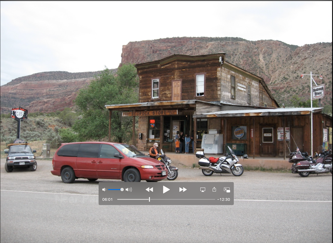
These things occurred because of the way the route was shaped, not due to our planning but just happenstance.
 
Then there was our 2013 trip out west where we took the “northern” route.  As you can see, there were only 44 routing points.  The rest, again, was up to the GPS.  Total miles traveled about 5,300 miles.  Time to travel, 16 days.


What did we see that was not planned. 


Although planned the views on the “Going to the Sun Highway” were spectacular.


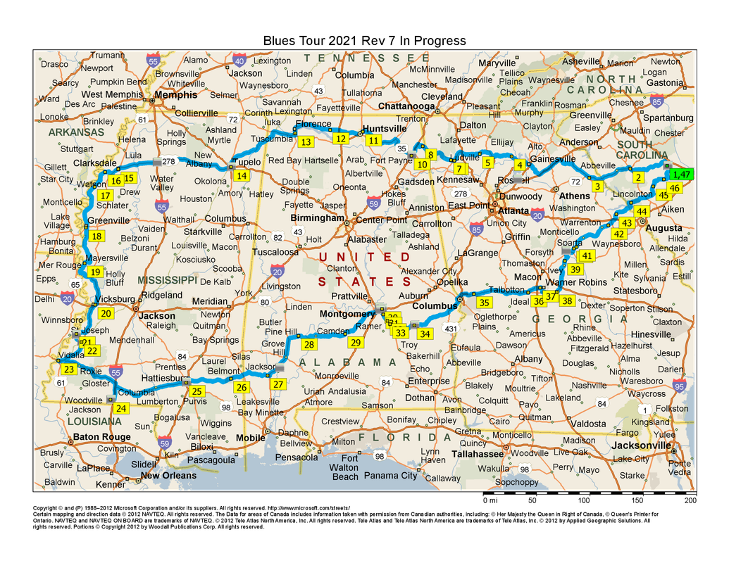
And finally there was our 2021 trip, The Blues Tour seven days and 1,700 miles, but 47 routing points.


The Lynyrd Skynyrd Memorial

Logged

Oss
Member
*****
Posts: 12579


The lower Hudson Valley

Ossining NY Chapter Rep VRCCDS0141


WWW
« Reply #15 on: December 16, 2023, 03:13:09 PM »

I had a waterproof gps holder named fred (flintstone) but no gps in 2014 when I rode out solo to Beverly Hills/Malibu via texas and then Zion then back to see Big BF and others on way back to
GOTF and up to Ossining with wild6 for the last 1800 or so miles

I would write the # of miles to next turnoff road and right or left on small pieces of paper

After about 7 or so lines of turns I pull over and turn the page over or flip to next one

Had my big print atlas and it worked like a charm until road construction in Alabama where the road was cut and when I got to the end that big ole smack took off my gps holder and there went fred  along with my sidestand spring and one air horn.   Thank goodness for bungee cords to hold the kickstand up and I plugged one hose with gum so horn worked

If one has a tank bag you dont need fred
« Last Edit: December 16, 2023, 03:16:08 PM by Oss » Logged

If you don't know where your going any road will take you there
George Harrison

When you come to the fork in the road, take it
Yogi Berra   (Don't send it to me C.O.D.)
Pages: [1]   Go Up
Print
Jump to: