I am heading to Harrisburg on 76 West then to 81 South. Weather permitting, at some point dropping down and enjoying the Blue Ridge Parkway. I am not in a rush, I plan on enjoying the ride. I hope to be in the Harrisburg area around 10:00 on the 11th. Jess from VA offered good advice, I have found in my life to always plan for the worst and hope for the best.
Well, if DonnySJ isn't talking, I'll talk to you.

As you say, time and weather permitting, you may not know, but the top two exits of Blue Ridge Parkway (BRP) is National Park (technically called Skyline Drive, but really just the top of BRP), and you have to pay to get on in Front Royal VA (unless you have a Sr pass). And those top two exits are beautiful and wonderful, but may add two hours riding time to the actual BRP. I think cost is now up to $15 (even for bikes, and good for 2-3 days, but not a week).
Speed limit on Skyline Dr is 35, but BRP is 45, and not quite as windy-twisty (and not quite as much patrolled by National Park Police, who tend to do so in light beige SUVs, which are marked, but not much more than decals, and a bit tricky to spot) (their MO is to sit on the side down little paths or in the woods and get you with radar, and not active patrolling).
So, to save a little money and time (and split the difference), you head down 81 South past Front Royal, exit onto 64 East around Staunton VA, run down a short hop, and get off around Rockfish Gap, to get on Mile Marker 1 of actual BRP, and take it all the way to Roanoke. Of course it takes longer than staying on 81, but the BRP down to Roanoke is certainly a great ride, and it won't take all day. Maybe actually only an hour or two more than 81, if you keep going and don't do many scenic turnouts. And it's always a good idea to fill/top up (just) before getting on BRP, as gas can be a little tricky to find along that trail. Another thing I've done, is stop and buy a sandwich/drink/chips, and had lunch on a scenic turnout.
One thing to remember, if it's raining (or likely to), the BRP can get a little (or a lot) foggy and hard (and sometimes impossible) to see, and deer and black bear are out all day on BRP (and it's better not to hit them). I've taken BRP many times up and down, but often pass on rainy days because of fog (freeway is safer in rain).
Another little thing on BRP/Skyine Dr is that it is real easy to get behind grandad in his Winnebago doing 20 knots plonking along forever, and double yellow is the rule (often for miles and miles without end), not the exception. That takes the fun out of the ride in no time. Lots of times, riding the center line looking ahead, you can plainly see a flat and fairly level spot where the Valk can do an easy pass in about 2.5 seconds all safe as can be, but it's still double yellow, and you can get a big ticket (maybe even reckless) for passing on it. I've done it a hundred times, but you want to make a good safe pass with no Park Police watching if at all possible. On the other had, if you ride that center and hit your brights for awhile, grandad might get the message and take a scenic turnout, but he might never do it. Just FYI.
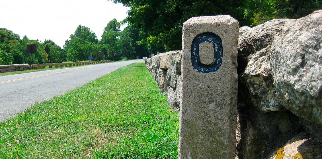
Here's a nice little site that gives the gas stations off BRP. The thing is, there are lots of exits with gas close by, but you can rarely see the stations from the Parkway. So you can get off and gas is right there over the hill, or a long ride away (esp way down farther South than you will be going). So printing this out and having it with you is a capital idea. The BRP mile markers are old concrete square posts sticking up about 18-24 inches (sometimes buried in the berm grass).
https://www.blueridgeparkway.org/gas-availability/I may take this exact route myself, after blasting out I-66 out of Sodom on the Potomac to I-81 South; weather permitting (time should be no problem).
Note that the alternate GREY route on this map is NOT the BRP.
https://www.google.com/maps/dir/Rockfish+Gap,+Rockfish,+VA+22920/Roanoke,+Virginia/@37.6144292,-79.8585447,9z/data=!4m13!4m12!1m5!1m1!1s0x89b364a3adf44bc3:0x53c7b3847882596f!2m2!1d-78.8570978!2d38.0325489!1m5!1m1!1s0x884d0c4d6aa966fd:0x249dbecbdbb0989b!2m2!1d-79.9414266!2d37.2709704
Here we are at mile marker 0 at Rockfish Gap.
And double yellow, easy to pass on, if no one's watching.
If you wanted to, and had the time, you could I-81 home after Inzane, but run down 64 east, and pay and go up the Skyline drive on the way home, then just hop back on 81 in Front Royal. Just a thought.