The story of the Cross Florida Barge Canal cannot be fully appreciated without some background information to place it in a broader, more historical context. Looking at it under a microscope, so to speak, will not provide a true understanding of the evolution of events… Why was such a waterway even considered? What were the pros and/or cons, the trade-offs of the overall impact and 'all' costs associated? What might it actually accomplish if anything?
As is the case with all events throughout human history, a little cherry-picked ‘accurate’ information yields little to no comprehension of reality… of the true nature of the overall series of events. Some individuals are vilified unjustly, while others are celebrated undeservedly… and few truly know how or why things actually happened the way they did… ‘Facts’ are spun to meet whatever political or ideological imperatives happen to present themselves at the moment… while ‘truth’ remains a casualty, like it so often does…
I returned to live in Florida again in 1970. At the time of my arrival, I knew nothing at all about the Canal or the issues involved with it. It was being hotly debated, though, and portrayed as solely an evil pro-business attempt to increase profits, jobs, and prosperity in that area versus the saviors-of-mother-earth tree-hugging environmentalists struggling valiantly in some David vs. Goliath battle to the death.
As was and still is typical, ‘facts’ were being taken out of context and wildly exaggerated or distorted, outrageous, tortuous claims were being made, and nasty personal insults were being exchanged by the ‘combatants’ on both sides… Predictably, most of us ordinary folks continued to wrestle in ignorance with what the right thing to do might actually be… all the while we were being frantically encouraged to take a stand on one side or the other, at one extreme or the other… to become either a hero or a heel…
The shape, structure, and location of Florida influence everything about it… its weather, environment, flora and fauna, and especially its history… both natural and human. Just prior to the last ice age, for example, the Florida peninsula as a landmass did not even exist, per se, at least above water. What today is the protruding jut of land housing Micky Mouse and millions of transplanted Yankees most are familiar with was actually only a few scattered barrier islands mostly along what is now the north-south ‘spine of uplands’. The actual continental ocean coastline was in what is presently southern Georgia.
At the peak of the last ice age, what had become the peninsula was approximately twice its present size… As the amount of planetary water trapped in the icecaps expanded and/or contracted, the size and shape of Florida changed proportionately. Many remains of earliest human life in this corner of the continent are presently under water in what is known as the ‘shelf’ that surrounds the peninsula. That feature extends well offshore along the western flank, and particularly in the big bend area of the Gulf of Mexico north of Tampa Bay.
The earliest known arrival by Europeans in present-day Florida was in 1513, when Ponce de Leon set foot in the northeast area near present day St. Augustine and a few miles south of Jacksonville. The myth of his search for the Fountain of Youth was not created until sometime following his visit. He did claim the ‘new’ territory for Spain, however, and later a colony was established. Hernando Desoto also visited the western and central portion of this ‘new land’ on his way to exploration of the area now comprising much of the southeastern United States.
The establishment (presidio/fort) of Pensacola was accomplished in 1559, pre-dating the settlement of St. Augustine by six years. It was destroyed by a hurricane only a few years later, however, and it was not re-built until 1698.
Because of the long and dangerous journey around all of the peninsula including the Keys, plus the length of time needed to make such a long passage by sail, typically 4-6 weeks or more, or making an even longer more difficult overland journey, the thought of a canal or water passage to shorten that and to reduce danger (both from weather calamities and the threat of attack from pirates and/or other foreign enemies) was first contemplated in the early days of Spanish rule.
As far back as 1565 with Governor Pedro Menéndez de Avilés, and as St. Augustine was being established, people dreamed of cutting a waterway across the peninsula to shorten the difficult voyage to the Gulf of Mexico, the Presidio of Pensacola, and to Mexico itself from the east coast of America and from Europe.
A canal was again reconsidered under British rule between 1763 and 1781. Because of the terms of the treaties ending first the Seven Years War (also known as the French and Indian War in North America) in 1763, then the American Revolution in 1781, a break in Spanish rule occurred in which the British actually controlled this then very sparsely populated land.
The British had set-up administration of the newly acquired territory with dual capitals… one in Pensacola, the other in St. Augustine, where the Spanish capital had been located. This dual capital arrangement continued following the return of the colony to Spain. Even though the population was small, the demographics of the people then present inclined them to consider themselves more as ‘loyalists’, so they did not join in the American Revolution.
Once the new nation of the United States had acquired Florida, officially in 1819, administration continued initially with two territorial capitals. Eventually the need for one central capital location was determined, resulting in the site of an old native village approximately midway between the two then principle cities at present-day Tallahassee becoming the new capital.
During all this time the small population of European descended inhabitants was almost entirely concentrated in the northern portion of the state and along the 'panhandle' with only a couple of remote outposts existing south of Fort King near present-day Ocala. It was recognized that a waterway to cut-off the majority of ‘wasteland’ that was the southern three quarters of the territory would be hugely desirable and would offer significant economic, safety, and time-saving advantages. The canal was a grand idea whose time had definitely come… again!
Soon after serious thinking about that tremendous engineering feat had begun yet again, railroads and steamships had come onto the scene, greatly reducing the urgency for such an undertaking. The American Civil War (and especially the aftermath) then virtually eliminated thought of such a canal for decades to come. The idea was never completely abandoned, however…
Planned Canal Route…
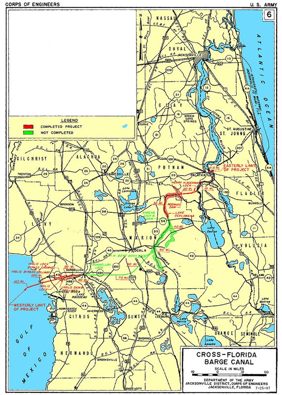
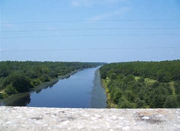
The eventual route envisioned for the canal was chosen because it offered the most efficient use of existing waterways and water availability… Because of land surface elevation changes to overcome (in the final plan) and the need to maintain constant water depths all along the canal, locks would have to be constructed, and large quantities of water ‘storage’ would be required for all of that to function properly and continually. Three rivers, the St. Johns (which flows into the Atlantic Ocean), Ocklawaha (a tributary which flows into the St. Johns), and Withlacoochee (which flows into the Gulf of Mexico), could be joined together with new canal work being necessary to link them over the uplands near Ocala. Also dams would be necessary for water ‘storage’ in newly created manmade lakes.
Florida has a delicate ecosystem, with fresh water being the overarching central issue. There is only one river flowing into any part of the peninsula, the Suwannee, and that only skirts the northwestern most corner of the actual ‘peninsula’ portion of the state. The overwhelming volume of fresh water available to near all of the peninsula comes entirely via rainfall. Additionally, the subterranean bedrock provides a floor, while low overall elevations throughout the entire state (345 ft. at its highest location, and that in the panhandle within sight of the Alabama state line) combine to limit the theoretical maximum capacity of the natural aquifer. Salt water along both coasts provide the lateral limits.
Normal fluctuations in annual rainfall combined with huge expansion of agriculture (with its irrigation), dramatic population increases throughout the state, ergo consumption, and particularly in the southern portion of the peninsula, have combined to reduce the volume of the freshwater aquifer itself over time… the source of all freshwater used for human activity, plant and animal life… everything really.
In addition, the ‘paving over’ of ever-increasing tracts of land that inexorably accompanies population and human activity expansion diverts large amounts of rainfall into runoff instead of down into the aquifer. This net reduction of ‘stored’ freshwater results in increased saltwater intrusion near the coasts, compounding the perpetual problems of replenishing the aquifer to meet ever growing demands. And, it provides a ‘Clarion Call to action’ for anyone interested in preserving the fragile environment that is the Florida ecosystem.
Throughout much of Florida’s history prior to WWII, the low overall population had prevented a canal of this sort from being deemed economically feasible when compared to other needs and priorities elsewhere. While it would have offered many advantages including ‘opening-up’ for development large areas and providing enormous economic opportunities, the costs, plus the still unresolved disease issues until the early 1900s (principally Yellow Fever and Malaria) kept an actual canal plan off the drawing board. Then came the Great Depression… but first…
United States territorial governments in Florida first started considering a canal in the 1820s, with the first legislation being the Canal Memorial sent to Congress in 1825. Andrew Jackson (President of the United States, 1829-1837) had supported the idea of a canal during his tenure as Governor of Florida in 1821, but he did not condone the use of taxpayers’ money for the project as President, and the project was rejected as unfeasible.
The next attempt to build a canal across the width of Florida was during the Great Depression. Calvin Coolidge’s River and Harbor Act of 1927, which had ordered the US Army Corps of Engineers to carry out surveys, the cost of which had been determined two years prior, would form the basis for the project which would see the first breaking of ground on a cross-Florida canal.
After extensive lobbying and political squabbling in 1935, President Franklin D. Roosevelt approved the use of 5 million dollars to construct the Atlantic-Gulf Ship Canal, primarily because it would provide jobs as part of his New Deal program.
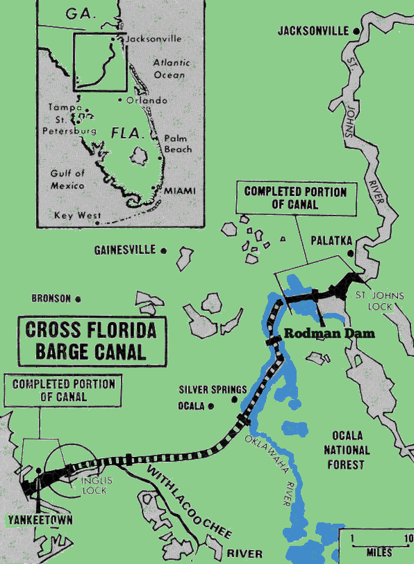
The St. Johns River, and to a lesser extent, the Ocklawaha River, had been important transport and trade routes for much of Florida’s history. The St. Johns is a wide river providing access from the Atlantic Ocean to the cities of Jacksonville (at one time known as Cow Ford) and Palatka. The Ocklawaha River is a much smaller, winding tributary of the St. Johns, which feeds into the latter just north of Lake George. The Ocklawaha meanders its way further inland before turning South and continuing all the way to Lake Griffin, near Leesburg.
Before railways were built, the Ocklawaha had been the route connecting Lake Apopka (near present day Orlando) with Jacksonville and the ocean. The Withlacoochee is on the other side of Florida, emptying into the Gulf of Mexico near Inglis and Yankeetown. It runs inland and then south to Green Swamp. Green Swamp also happens to feed the Ocklawaha, though indirectly. Had the canal been finished, the two halves would have come together just south of Ocala.
Construction began in 1935. That canal was to be a sea level canal, meaning it would cut straight through any mountains or hills along its path, and would not require any locks to change ships’ elevation. Due to political opposition from Secretary of the Interior Harold Ickes, who claimed that a sea level canal would destroy Florida’s aquifers, work on the canal was cancelled within a year.
Other political factors also contributed to the cancellation of the Atlantic-Gulf Ship Canal, such as a need for disaster relief elsewhere in Florida, and pressure from the railroads and the growing city of Miami for whom the canal offered considerable competition. The Depression Era canal attempt ended with only a few miles of ditches dug, some abandoned structures, and $5.4 million in wasted federal appropriations.
The cross-Florida canal idea was revisited in 1942 as World War II was in full swing and thousands of tons of shipping were being lost to German U-boats off the coast of Florida. The canal was proposed as a means for ships to avoid the U-boat infested waters of the Atlantic Coast when making trips from the US East Coast to the Gulf of Mexico.
Construction of the canal was approved as a wartime defense measure; however, Congress was still divided on its overall value, resulting in a tie vote that was only settled in favor of the canal by the vote of Vice President Henry Wallace. Despite being approved, the canal was never funded; unsurprising considering the mixed response from Congress in the first place. Political pressure also influenced this decision, as there was concern that had a canal been built it would rob port traffic from Palm Beach, Fort Lauderdale, and Miami. However, the men who served in World War II, and saw the loss of life at the hands of the U-boats firsthand, would remember the government’s indifference to what they saw as a life-saving measure. Some of them would later go into politics and would lead the charge for the second and final attempt at actual construction of a canal in the 1960s.
Approved in 1963 by President John F. Kennedy, work started in 1964 under President Lyndon B. Johnson. The Cross Florida Barge Canal project was born out of a political struggle much too in depth to cover in even greater detail here. The project would run from 1964 to 1971 and follow much the same route that the 1930s canal would have.
It was intended that the canal would benefit central Florida militarily, economically, and recreationally. The US Army Corps of Engineers was put in charge of construction of the canal and broke ground in February 1964.
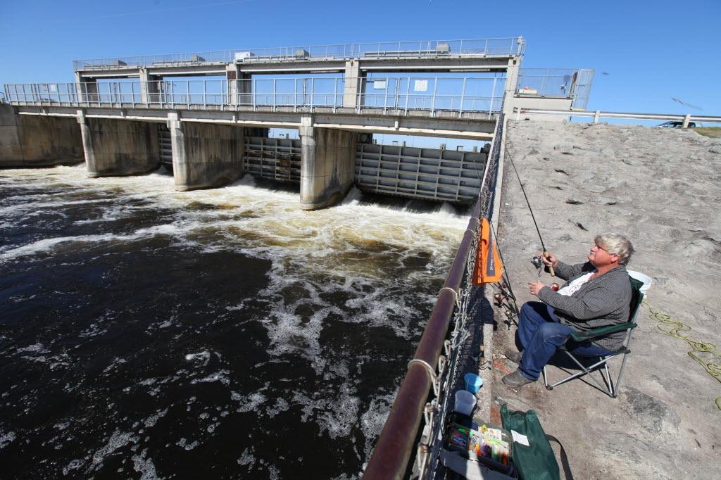
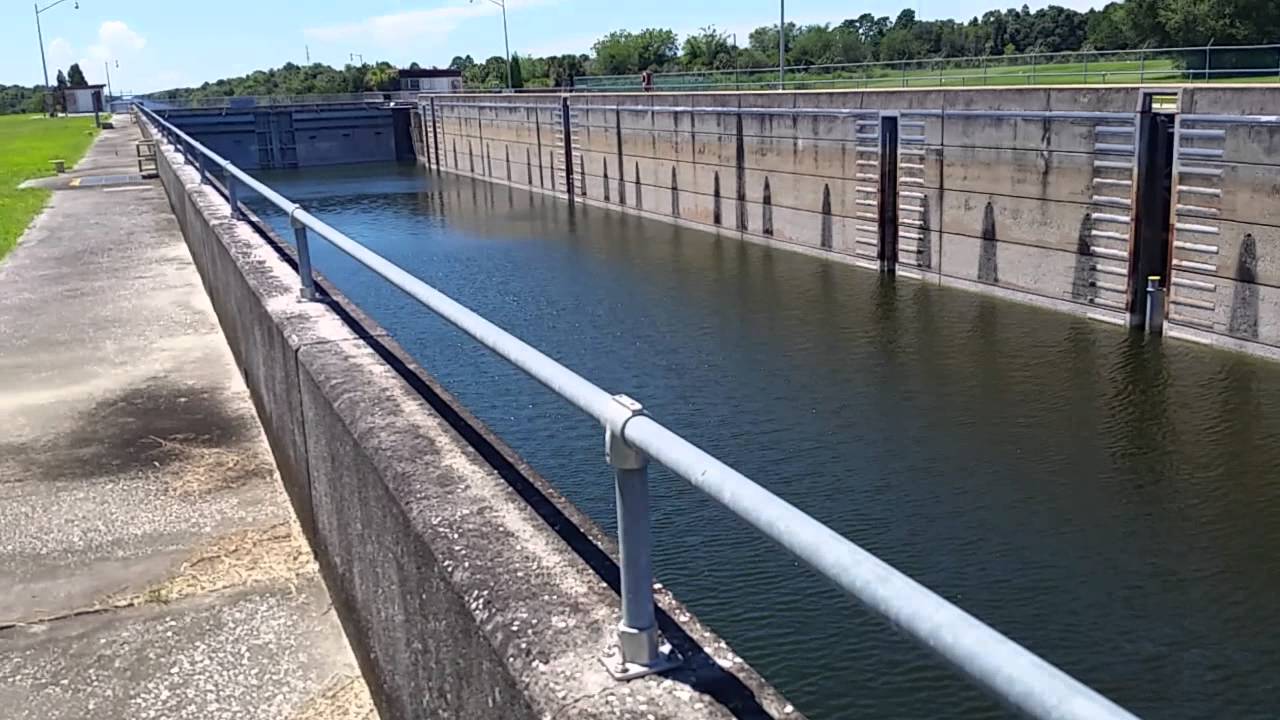
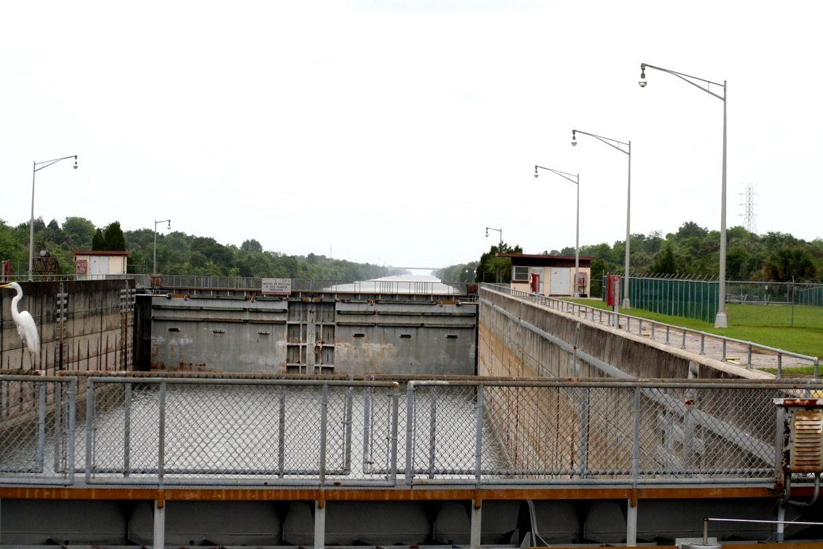
Only two locks, Buckman and Inglis, were completed on the CFBC, with a third, Eureka, left unfinished. The first lock built was originally known as the St. Johns Lock, but was renamed Henry H. Buckman Lock, or simply Buckman Lock. Buckman Lock is the closest lock on the canal to the St. Johns River. It sits on a man-made portion of the canal connecting Rodman Reservoir and the St. Johns, bypassing the lower portions of the Ocklawaha River.
Kilpatrick Dam creating the Rodman Reservoir
 img host
Buckman Lock near Rodman
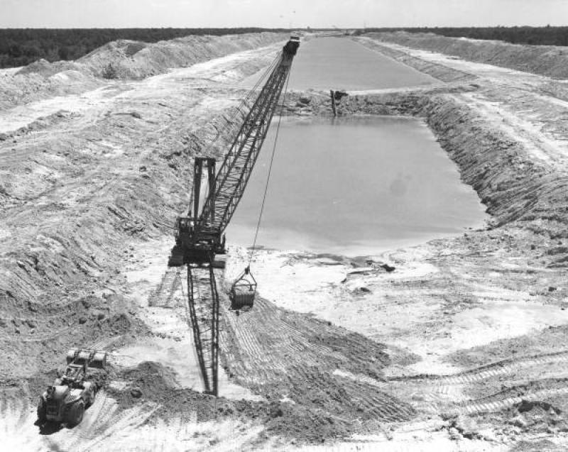
Portion of Canal dug between Rodman and Buckman
Canal being dug
 picture upload site
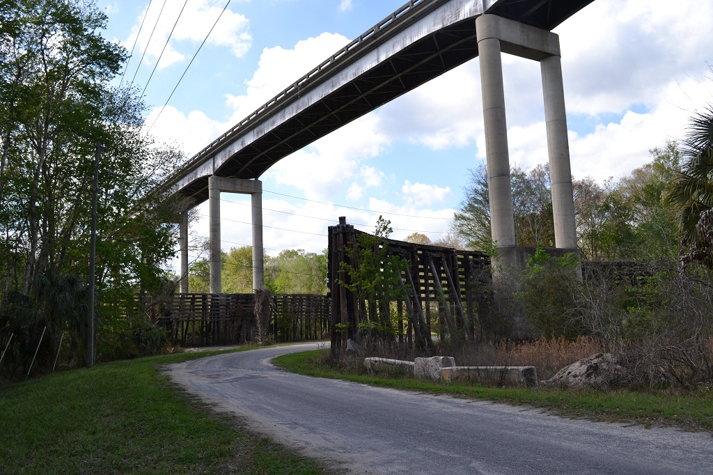
Many new high bridges were actually completed in preparation for expected large boat/barge traffic, this one near Eureka
Dam near Inglis
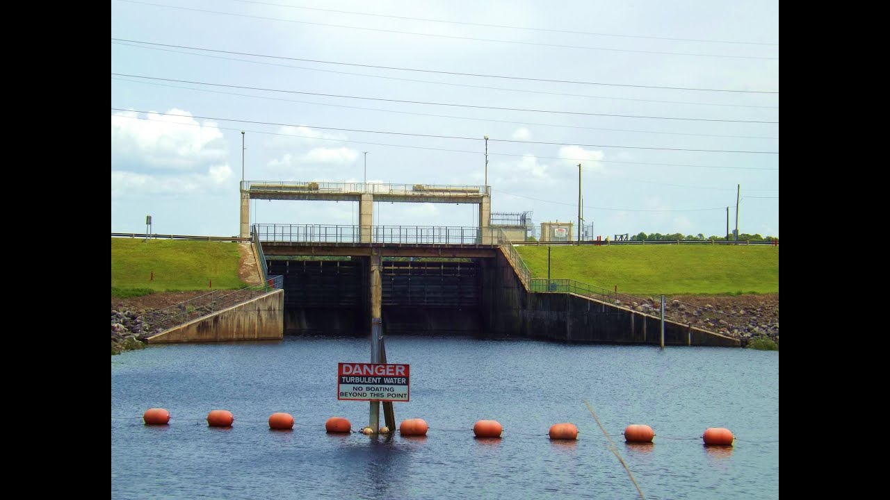
Lock near Inglis
The canal idea finally died in 1971, when President Richard Nixon bowed to pressure and halted the project. It is likely dead and gone once and for all now, I would guess. As with nearly all such projects, it was both good and bad, needed and unnecessary, helpful in some ways, harmful in others. After centuries of consideration, what eventually killed it were changes in the world around it, changing relative value and human values with attendant costs vs benefits analysis, plus the ebb and flow of political influence and relative power, or lack thereof.
It had become a small boat/barge canal idea in a super tanker ship economy… It would have done extensive damage to the fragile ecosystem that is the Florida peninsula, and to its aquifer in particular, while it would have created far less positive economic advantage than it might have at an earlier time. Naturally, much posturing and pontificating accompanied the concept from its beginning all the way to its eventual end, with the net result of the better, or at least less bad, choice eventually being made… Of course, other opinions may vary.
DDT
Note: All pictures were taken from other sources on the internet. The part of this piece starting with the Great Depression was taken mostly from an article found on the internet but substantially edited. The majority of this, however, is the result of my own reading, memory, and distillation, digestion, interpretation, and perception of events involved.


