|
sandy
|
 |
« on: October 14, 2010, 11:17:04 AM » |
|
Tuesday morning, my son-in-Law and myself left Mesa, AZ and rode the Devil's Highway in Eastern AZ. We spent the night in Alpine at over 8,000' elevation. Just before arriving at Hannigan's Meadow, my GPS said 9,287' elevation. (Cheaha MTN my butt!!) DH use to have the number 666 but certain groups in AZ went to the state legislature years ago. They requested a name change so it's now 191 but to the oldtimers here it's still the Devil's Highway. There's over 600 hairpin turns in a bit under 90 miles. Not much traffic either. We saw about 15 cars in the 90 miles. The route home took us across the White MTN Apache and San Carlos Apache reservations. Then down through Devil's Canyon near Superior AZ. (nowhere near DH). Had frost on the seat in Alpine and came home to 100 deg in Mesa. http://s982.photobucket.com/albums/ae310/sandyal55/DevilsHighway/ |
|
|
|
|
 Logged
|
|
|
|
rainman
Member

Posts: 1838
Steve ( rainman) Eads
Bloomington Indiana
|
|
« Reply #1 on: October 14, 2010, 12:19:49 PM » |
|
looks like a good ride I am from indiana could you give the route you guys took. like to see it for myself
thanks
|
|
|
|
|
Logged
|
|
|
|
hubcapsc
Member
Posts: 16824
upstate
South Carolina
|
|
« Reply #2 on: October 14, 2010, 12:33:41 PM » |
|
cool... 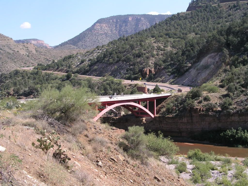 -Mike |
|
|
|
|
Logged
|
|
|
|
Cruzen
Member
Posts: 491
Wigwam Holbrook, AZ 2008
Scottsdale, Arizona
|
|
« Reply #3 on: October 14, 2010, 12:37:28 PM » |
|
Sandy, I did that route in 2008 and again in 2009. Personally due to all the truck entrances along the way the constant potential for gravel on some of the curves, the number of unguarded hairpin curves, the drastic changes in elevation, the potential of herds of deer or other critters and the length of the route I find that ride to be much more challenging than the Dragon. The down side in New Mexico is a bit easier and still called 666. Every year a group sponsores a ride over that loop going up the Arizona side and coming down the NM side and some members have been known to cover the 191 signs with temporary 666 signs.  In 2008 on our way up heading North, we saw one of those bus size 50-55 ft motor homes pulling a full size Jeep heading South. The smell of burning brakes was following it down the mountain. We're almost done with them 100 degree days. This summer has seemed endless. |
|
|
|
|
Logged
|
The trip is short,
enjoy the ride,
Denny
|
|
|
|
sandy
|
|
« Reply #4 on: October 14, 2010, 01:48:12 PM » |
|
The Devil's Highway is a road from Clifton AZ to Alpine AZ. It runs parallel to the NM border. I suppose mapquest or Google could lay it out for you. Our whole route was fron Mesa to Safford, then to Clifton and up to Alpine. The next morning, we took 260 to Hondah near Pinetop. Then we took the loop through Whiteriver on the Apache reservation. Then South to Globe and down HW 60 back to Mesa.
|
|
|
|
|
Logged
|
|
|
|
rainman
Member
Posts: 1838
Steve ( rainman) Eads
Bloomington Indiana
|
|
« Reply #5 on: October 14, 2010, 04:06:30 PM » |
|
THANKS SANDY WIFE AND I ARE GOING TO HAVE TO TRY LOOKS LIKE MY KIND OF RIDEING
|
|
|
|
|
Logged
|
|
|
|
|
RP#62
|
|
« Reply #6 on: October 14, 2010, 06:29:51 PM » |
|
Great pics Sandy. One of these days we're going to make that ride with you.
-RP
|
|
|
|
|
Logged
|
|
|
|
NCGhostrider
Member
Posts: 592
A bad map and a long ride in Northern New Mexico!
Jacksboro, TX

|
|
« Reply #7 on: October 14, 2010, 07:07:01 PM » |
|
Sounds like a great ride! I will have to put that one on the list!!!  |
|
|
|
|
Logged
|
#6674 99 I/S Why aren't we riding? Anyone? Anyone? |
|
|
|
Kendall
|
|
« Reply #8 on: October 14, 2010, 08:03:48 PM » |
|
Great Pictures!! Luv that ride . Thanks 4 the post
|
|
|
|
|
Logged
|
|
|
|
|
sandy
|
|
« Reply #9 on: October 15, 2010, 08:09:48 AM » |
|
cool... -Mike This bridge is over the salt River Canyon about 70 miles NE of Globe, AZ. |
|
|
|
|
Logged
|
|
|
|
|
alph
|
|
« Reply #10 on: October 17, 2010, 12:37:59 AM » |
|
our names are written with black marker on that stone wall!! i'm sure the suns burnt it off by now!! my wife didn't like that drive. there's a burnt out car over the cliff, near were that wall is, or atleast there was six years ago.  |
|
|
|
|
Logged
|
Promote world peace, ban all religion. Ride Safe, Ride Often!!  |
|
|
|
RP#62
|
|
« Reply #11 on: October 17, 2010, 08:16:54 AM » |
|
our names are written with black marker on that stone wall!! i'm sure the suns burnt it off by now!! my wife didn't like that drive. there's a burnt out car over the cliff, near were that wall is, or at least there was six years ago.
Well then she would just love Fish Creek Canyon on the old Apache Trail. -RP  |
|
|
|
|
Logged
|
|
|
|
Cruzen
Member
Posts: 491
Wigwam Holbrook, AZ 2008
Scottsdale, Arizona
|
|
« Reply #12 on: October 18, 2010, 06:25:19 AM » |
|
I am very thankful to be living in Arizona for despite all the political crap going on around here and the need to carry a gun, we have one of the most diverse riding environments and long riding seasons of any state. The Devils Highway is just one example. Route 89A from Prescott to Jerome through Sedona/Oak Creek Canyon to Flagstaff in the Fall and that Route 60 Sandy talked about or the Coronado Highway up to My Lemon near Tucson are others. In addition Arizona is a great jumping off point for other great riding states such as Colorado where the San Juan Skyway is a great ride, Utah and parts of California. It seldom gets boring unless you’re coming home to 110 degree heat.  |
|
|
|
|
Logged
|
The trip is short,
enjoy the ride,
Denny
|
|
|
|